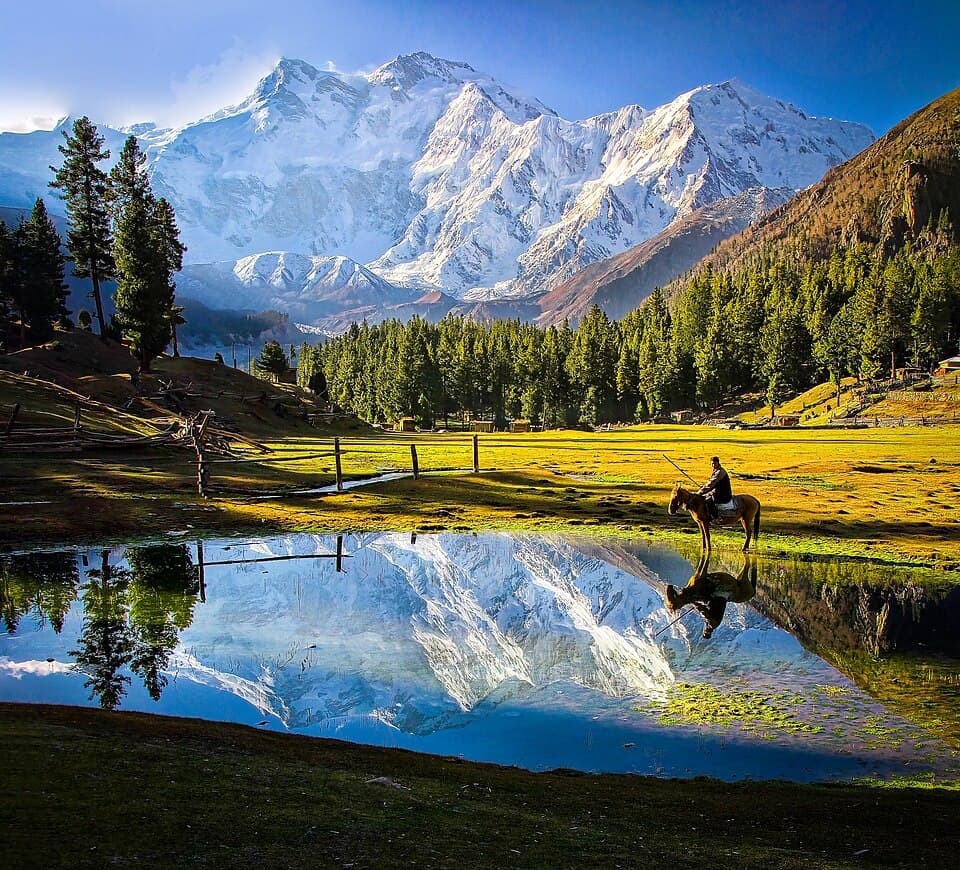
There are mountains you look up at, and then there is Rakaposhi, which seems to lean over you. Stand in the meadow beneath it and the snow ridge sits so high overhead that it changes the weather around you, throws cold air down the glacier and turns the afternoon light a clean, hard white. The walk to its base camp is one of the most rewarding short treks in the Karakoram — close enough to attempt in a long weekend, wild enough to feel like a proper expedition.
At a glance
- Region: Nagar district, Gilgit-Baltistan
- Duration: about 3 days
- Difficulty: Moderate
- Best months: May–October
- Starting point: Minapin village
- Indicative price: from $220 — message us for a tailored quote
- Headline view: Rakaposhi (7,788 m) and the Minapin (Pisan) Glacier
The mountain that rises from nowhere
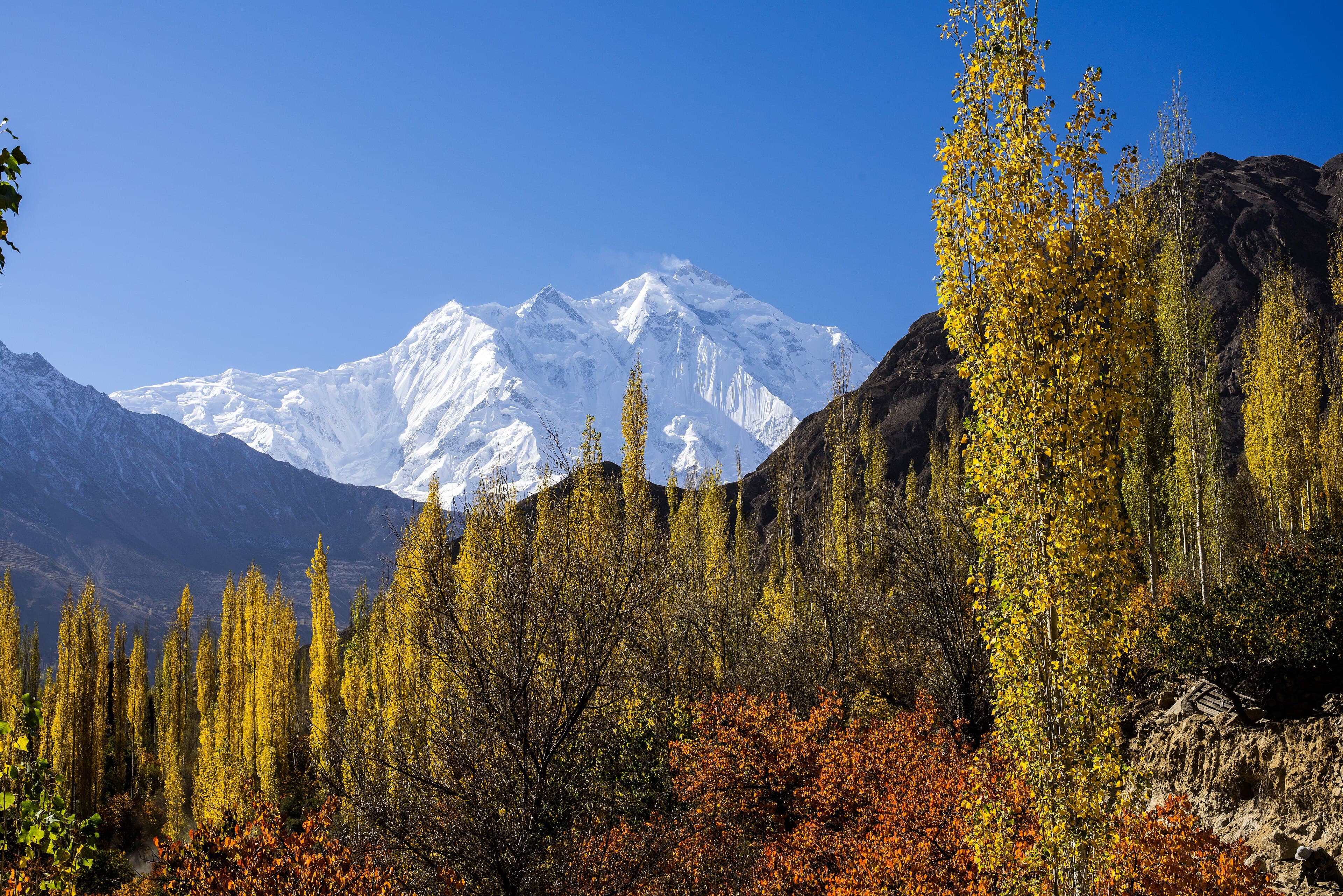
Rakaposhi — known locally as Dumani, "mother of mist" — stands 7,788 metres high in the Karakoram, set between the Nagar and Bagrote valleys. Its reputation rests on a single, startling fact: it climbs almost 6,000 metres uninterrupted from the valley floor to the summit. There is no foothill range to soften the view, no gradual build-up. You go from orchards and apricot trees to permanent ice in one sweep of the eye, which makes it one of the most dramatic continuous vertical rises anywhere on earth.
That scale is the whole reason to walk in close. Most travellers meet Rakaposhi at the roadside viewpoint on the Karakoram Highway, where you can sit with a cup of apricot tea and a full-frontal view of the peak. It is genuinely lovely, and worth an hour. But the base camp trek puts you at the foot of the mountain, where the glacier groans, the air thins and the summit feels less like a postcard and more like a presence.
The route: Minapin to Tagaphari
The classic trek begins in Minapin, a green Nagar village a short drive off the Karakoram Highway. From there the path climbs steadily through pine forest, gaining height as the trees thin and the valley opens out.
The first staging post is Hapakun, a clearing among the last of the forest and the beginning of the summer pastures. This is where the rhythm of the walk settles — slower steps, longer views back down the valley, the first proper sense of altitude in your legs.
From Hapakun the trail continues up to Tagaphari, the meadow that serves as base camp. Here the ground levels into alpine pasture beneath the mountain, with the Minapin (Pisan) Glacier spilling down on one side — a great river of broken ice and grey moraine that you can hear long before you reach it. Tagaphari is the reward: a grassy shelf with Rakaposhi filling the sky, and on clear evenings the snowfields turning gold and then rose as the sun drops.
This is working land as much as wilderness. In summer, Nagar shepherds bring their flocks up to these pastures, and you may share the meadows with grazing animals, stone huts and the quiet daily routines of mountain life. It is one of the trek's gentler pleasures — a reminder that these high valleys have been lived in, not just admired, for generations.
Difficulty and who it suits
The Rakaposhi Base Camp trek is graded Moderate. It does not require technical mountaineering skills, ropes or glacier crossings, but it is a genuine uphill walk at altitude with some steep, sustained sections. You need a reasonable level of fitness and to be comfortable on rough, rocky ground for several hours at a stretch.
It suits:
- First-time Karakoram trekkers who want a real summit view without a multi-week commitment
- Reasonably fit walkers, including older travellers who take a steady pace
- Families with active teenagers who are used to hill walking
- Anyone short on time who still wants to stand beneath a 7,000-metre giant
If you have hiked in the Alps, the Scottish Highlands or any proper hill country, you will recognise the effort. The main adjustment most visitors underestimate is altitude rather than distance — see the safety section below.
Best time and weather
The trekking window runs May to October. Within that, the shoulders and the heart of the season each have their character:
- Late spring (May–June): lush green pastures, wildflowers and snowmelt streams; lingering snow possible higher up early in the season.
- High summer (July–August): the most reliable weather and longest days, though the valleys lower down can be warm.
- Autumn (September–October): crisp air, the clearest mountain views of the year and the famous golden colours as the slopes turn — many regulars consider this the finest time to walk in.
Mountain weather is its own authority and can shift quickly at any time of year. For a fuller breakdown of seasons across the region, our guide to the best time to visit Gilgit-Baltistan is a good companion read.
What to pack
You don't need expedition kit for this trek, but you do need to dress for big swings in temperature — warm orchards at the bottom, near-freezing nights at base camp. Think in layers rather than single heavy items:
- Layers: a moisture-wicking base, a warm mid-layer (fleece or light down) and a waterproof, windproof outer shell
- Footwear: broken-in, ankle-supporting hiking boots with good grip for rocky, uneven ground
- Sun protection: the mountain sun at altitude is fierce — high-factor sunscreen, lip balm, sunglasses and a brimmed hat
- Warmth for camp: a hat, gloves and an extra layer for cold evenings and early starts
- Personal extras: a refillable water bottle, a headtorch, and any personal medication
We handle the camping equipment, so you can keep your own pack light and focused on clothing, water and personal items.
Acclimatisation and safety
Altitude is the one part of this trek to take seriously. Base camp sits high, and the climb from Minapin gains a lot of height in a short time, so the sensible approach is to ascend at a measured pace, stay well hydrated and listen to your body rather than push through warning signs like persistent headache or nausea.
We prioritise safety with first-aid-trained local teams who know these slopes intimately, build in proper acclimatisation, and monitor the group daily. Mountains carry real risk, and we plan around that rather than pretend it away — which, more often than not, simply means a slower, more enjoyable walk with time to take it all in.
How GAC runs the Rakaposhi trek
Gilgit Adventure Club has been guiding in these valleys for 12+ years, and our Rakaposhi Base Camp Trek is run entirely by local guides, drivers and cooks who were born in Nagar and the surrounding valleys. That local depth shows in the small things: knowing which campsite catches the morning light, reading the weather off the ridgeline, and cooking a proper hot meal at Tagaphari after a long day's climb.
A typical trip includes experienced local guiding, camping equipment, meals on the mountain, and maintained, insured transport to and from the trailhead. It is graded Moderate, runs over about 3 days, and starts from $220 — indicative, so message us and we'll put together a tailored quote and itinerary to suit your dates, fitness and travel plans.
If you'd like to pair it with more time in the region, it slots neatly alongside our other treks, and we can arrange a comfortable 4x4 and driver for the journey up the Karakoram Highway.
Frequently asked questions
How fit do I need to be for the Rakaposhi Base Camp trek?
Reasonably fit and comfortable walking uphill on rough ground for several hours. There's no technical climbing, but the sustained ascent and altitude make it a proper effort. Regular hill walkers and active families generally manage it well at a steady pace.
Do I need a guide, or can I trek independently?
You can technically walk in independently, but a local guide adds real value — route knowledge, weather judgement, acclimatisation pacing, camp logistics and first-aid cover. For most international visitors, going with a local team makes the trek both safer and far more relaxing.
Is the roadside viewpoint worth it if I'm doing the trek?
Yes. The Karakoram Highway viewpoint, with its apricot tea and full-frontal view of the peak, is a lovely contrast to the base camp experience and easy to fit in around the trek. It's a fine place to first take the measure of the mountain before you walk in beneath it.
What's the best month to go?
Anywhere in the May–October window works. September and October often bring the clearest views and golden autumn colour, while July and August offer the most settled weather and longest days.
A standing invitation
Few places reward a short walk so generously. Three days from Minapin and you're standing on a high meadow with one of the world's great mountains rising almost six kilometres into the sky in front of you, a glacier at your feet and a hot meal waiting. If that's a morning you'd like to wake up to, tell us your dates through the trip planner and we'll help you plan it properly — at the right pace, in the right season, with people who call these valleys home.