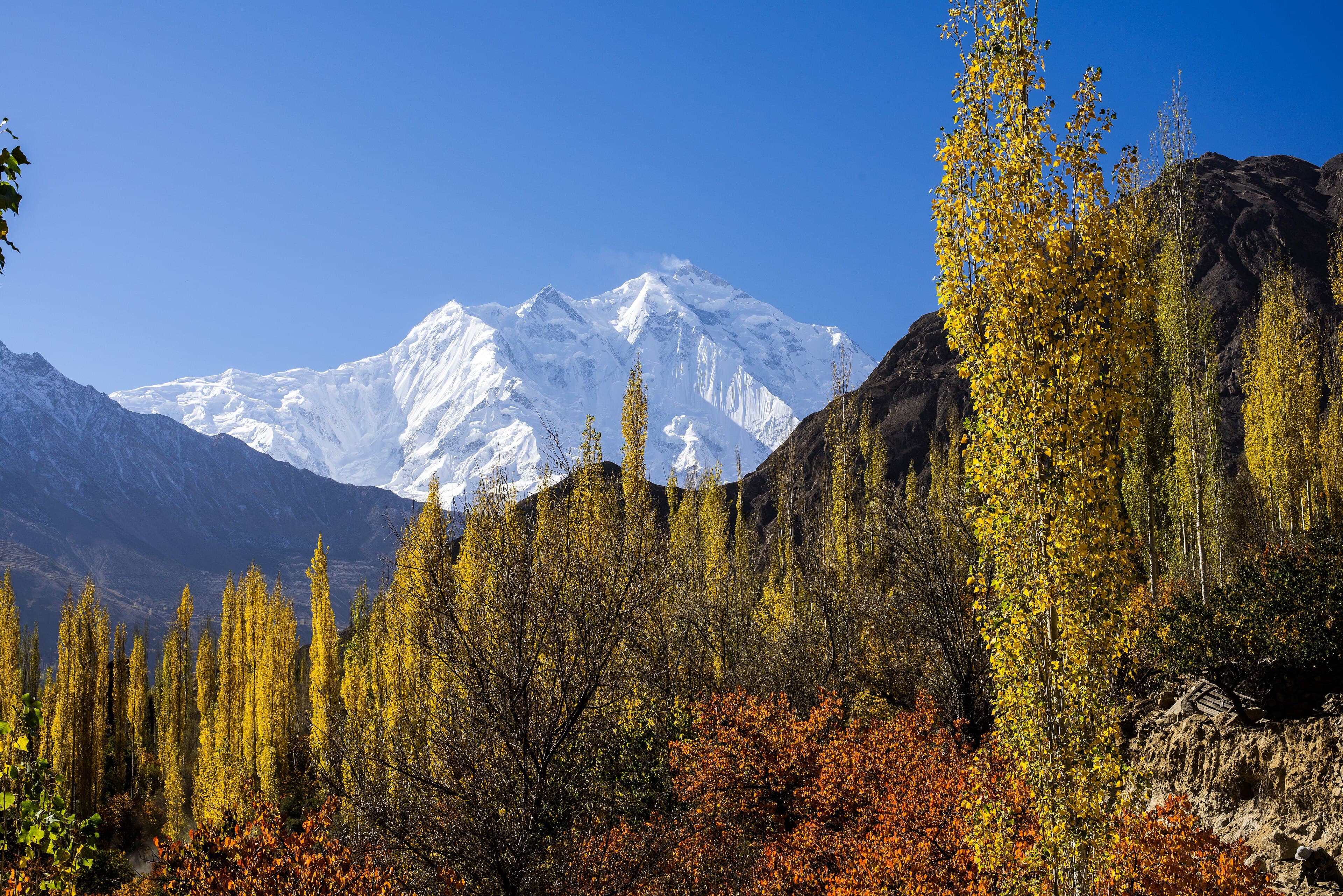
There is a moment, somewhere north of Gilgit, when the valley narrows and the road tilts upward and a wall of ice and granite simply fills the windscreen. That is Rakaposhi, and you have only just begun. The Karakoram Highway is not a route between places so much as a place in its own right — and driving it slowly, with the windows down and apricot tea waiting somewhere ahead, is one of the finest things you can do in this part of the world.
What the Karakoram Highway actually is
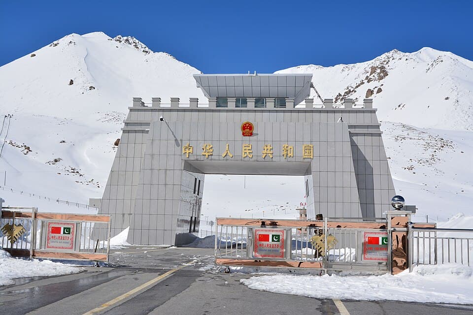
The Karakoram Highway — the KKH, officially national highway N-35 — links Pakistan and China, climbing to the border at the Khunjerab Pass at 4,693 m, the highest paved international border crossing in the world. It was carved through some of the planet's most unforgiving terrain, and it is often called the "Eighth Wonder of the World" with very little exaggeration.
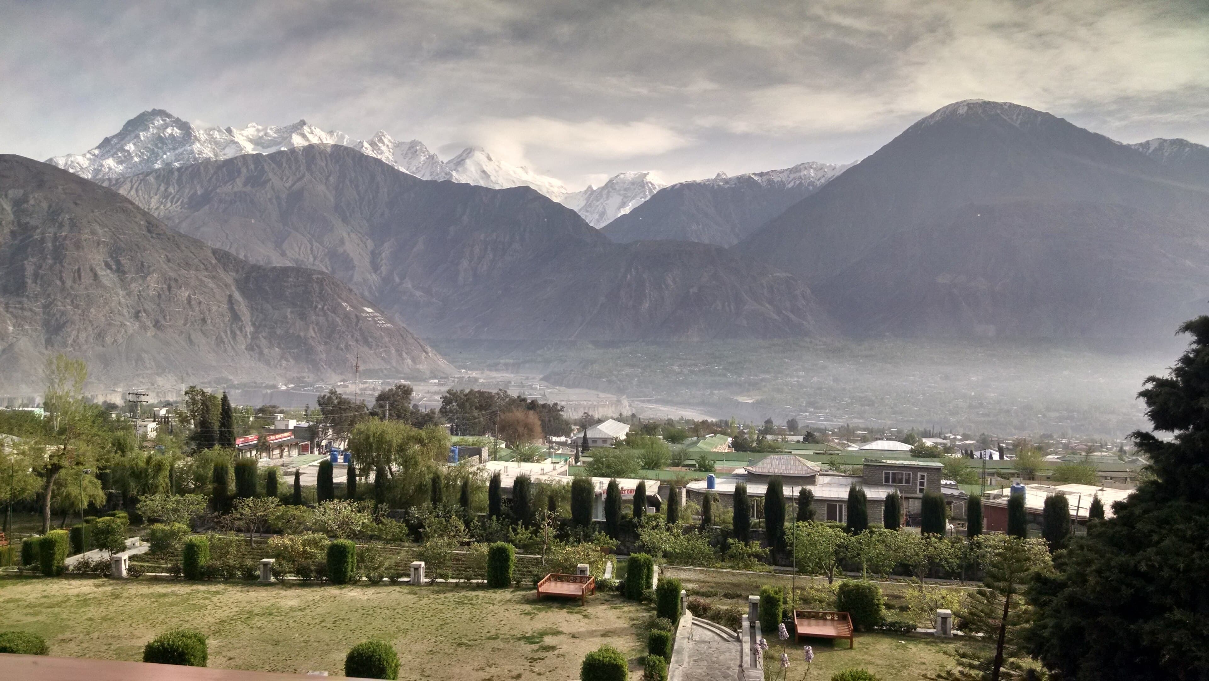
Inside Gilgit-Baltistan, the highway threads alongside the Hunza and Indus rivers, through scenery that shifts from arid gorge to glacier-fed turquoise within the space of an hour. You will pass orchards clinging to terraces, centuries-old forts watching over the valley, and peaks that scarcely seem real. It is the kind of road where the journey genuinely is the destination — and where it pays to allow far more time than the map suggests.
The route, north from Gilgit
Most travellers use Gilgit as a base and head north into Hunza and Nagar, with the Khunjerab Pass as the grand finale. The distances are modest, but the road, the photo stops, and the simple pull of the landscape mean you will move slowly. That is the point.
A relaxed approach is to break the journey into legs: Gilgit to Karimabad, a night or two in Hunza, then a day trip onward to Passu and Sost, and a separate, weather-permitting push to the pass itself.
Top stops north of Gilgit
- Rakaposhi viewpoint (Nagar) — a roadside terrace where you sip apricot tea beneath the 7,788 m peak, one of the few places on earth you can drink tea this close to a mountain this size.
- Karimabad, Hunza — the cultural heart of the valley, home to Baltit Fort (founded in the 8th century, its present form around 700 years old) and Altit Fort, the oldest surviving monument in Gilgit-Baltistan.
- Attabad Lake — a startling turquoise lake formed in January 2010 when a landslide dammed the Hunza River; today a place for boat rides and long, slow lunches by the water.
- Passu — for the jagged Passu Cones and the swaying Hussaini suspension bridge, a rite of passage for anyone with a head for heights.
- Sost — the last town and customs post before the frontier, and the practical staging point for the final climb.
- Khunjerab Pass — the summit of the drive at 4,693 m, set within Khunjerab National Park, where the air is thin, the marmots are bold, and China lies just over the line.
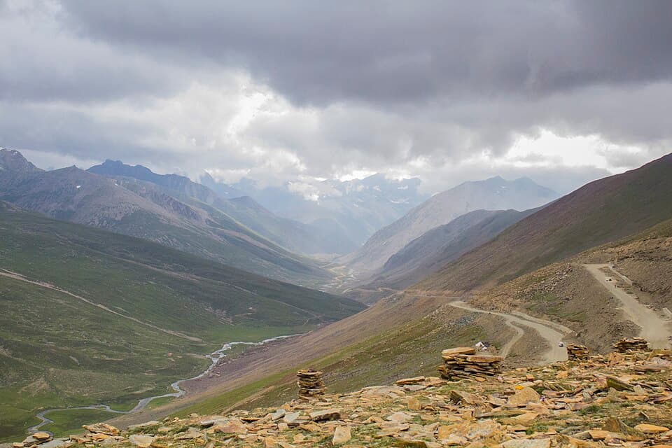
Coming in from the south: the Babusar Pass
If you are driving up from Islamabad or the Kaghan Valley rather than flying into Gilgit, the most scenic summer entrance is over the Babusar Pass at 4,173 m, at the top of Kaghan. It is a spectacular way to arrive — the road crests the pass and the whole of upper Gilgit-Baltistan seems to open out below you. It is a summer route, though, snowbound for much of the year, so the timing of your trip matters as much as the route you choose.
Best time to drive, and seasonality
The KKH through Gilgit-Baltistan is rewarding across the warmer months, but the high ground keeps its own calendar. The Khunjerab Pass is seasonal and closed by snow in winter; the higher sections — the pass and the Babusar approach — are at their best in summer and early autumn, when the roads are clear and the days are long.
Each season has its own character. Spring brings blossom across the Hunza terraces. Summer opens every pass and fills the valleys with green. Autumn, for many of us, is the quiet favourite: the poplars turn gold, the light goes soft, and the crowds thin out. Winter, by contrast, closes the high passes entirely, though lower Hunza remains starkly beautiful for those who don't mind the cold.
If you are weighing up exactly when to come, our companion guide on the best time to visit Gilgit-Baltistan goes into the seasons in more detail.
Self-drive or a 4x4 with a local driver?
This is the question every road-tripper asks, and the honest answer depends on you.
Self-drive gives you total freedom — stop where you like, linger as long as you want. But the KKH is a serious mountain road. Conditions change quickly, fuel and reliable mechanics are sparse beyond the main towns, and high-altitude driving on narrow shelves above a river is not the place to be learning the ropes. You will also spend a good deal of energy navigating rather than looking out of the window.
Hiring a 4x4 with a local driver trades a little independence for a great deal of ease. A driver who grew up in these valleys knows which stretches need care, where the best apricot tea is, when to pause for the light, and how to read the weather on the high sections. You get to simply be a passenger to the scenery.
There is a middle path, too: GAC rents out maintained and insured 4x4s, with an optional local driver. Some travellers take the wheel themselves on the easier, lower stretches and bring a driver for the high passes — a sensible blend of freedom and reassurance. You can see the vehicles and terms on our rent-a-car page.
Safety and road conditions, honestly
The KKH is a genuinely manageable drive when treated with respect, and it carries everything from local buses to fully loaded trucks every day. That said, this is high-mountain country, and a few things are simply true. Rockfall and the occasional landslide can affect the road, particularly after rain or snowmelt. The high passes can close at short notice for weather. Mobile signal is patchy. And altitude is real — drink water, ascend gradually, and don't rush the pass on your first day in the valley.
None of this should put you off. It is the reason a little local knowledge goes a long way, and why our teams are first-aid trained and our vehicles maintained and insured. Preparation turns the KKH from intimidating into unforgettable.
How GAC runs it
We have been guiding Gilgit-Baltistan for more than twelve years, with drivers and guides born in these valleys — the people who actually know which bend frames Rakaposhi best at dawn. Our Hunza Valley Jeep Safari runs from $160, about two days, indicative — message us for a tailored quote — and takes in the headline stops with the kind of timing and local access that's hard to plan from afar.
We work WhatsApp-first and send a tailored itinerary within 24 hours, so you can shape the trip around your pace, your interests, and the season you're travelling in. You can browse the full range on our tours page.
Frequently asked questions
How many days do I need for the KKH from Gilgit to Khunjerab?
Allow a few days at minimum so you're not rushing the high sections or the altitude. Many travellers base in Hunza, explore at leisure, and take a dedicated day for the Khunjerab Pass when the weather is settled. We'll help you pace it sensibly when we build your itinerary.
Is the Khunjerab Pass open in winter?
No. The pass is seasonal and closes with the winter snow. The high ground — the Khunjerab Pass and the Babusar approach from the south — is best in summer and early autumn.
Do I need a 4x4?
For the main highway you don't strictly need one, but a maintained 4x4 gives you confidence on rougher side roads, at altitude, and in changeable weather. We offer 4x4s with or without a local driver via our rent-a-car service.
Before you go
The Karakoram Highway rewards travellers who slow down — who stop for the tea, walk the bridge, and let the light do its work over Attabad Lake. Get the season right, choose how much driving you actually want to do, and the rest tends to look after itself.
When you're ready to map it out, send us a note via WhatsApp on +92 348 991 0011 or through our trip-planner, and we'll come back within 24 hours with an itinerary shaped around you.